 |
Ohio Automation, Inc. |
|
Mining Ventilation Software and More |
||
Engineering Software since 1985 |
||
| Home | AboutUs | MineSimU | MineVent | MineFire | MineWater | Downloads | ContactUs | Support | Services | Prices | Customers |
Call 740-596-1023 Today! |
||||||||
| QuickSurf Terrain Modeling Software |
||||||||
| Examples and Useful Applications | ||||||||
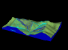
| Topography | ||||||||
Quicksurf generates contours or surface meshes for topography starting from x, y, z files, digital elevation models or extracted drawing entities, such as spot elevations or contour polylines. 3D breaklines defining elements such as building pad perimeters, roads or geologic faults may optionally be used. Contours may be based on a TIN, grid or triangulated grid. Contouring directly on the TIN (Triangulated Irregular Network) is common in civil site design. Contouring on the grid allows for smooth curved surfaces between your data points. Contouring on the triangulated grid (unique to Quicksurf) allows both smooth curving surfaces and exact honoring of breaklines. Optional contour line indexing, annotation, hachuring, and color options are available. More about topography. Top of page Back to Examples |
 |
|||||||
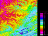
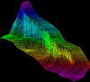
| Slope Analysis | ||||||||
Quicksurf can display your surface colored by surface slope in percent or degrees, complete with colored legend showing the slope breakdown. Iso-slope contours may be created and draped onto the surface in 3D. Creating slope analysis maps is quick, easy and flexible. A larger version of this image is available on the topography page. Top of page Back to Examples |
 |
|||||||
| 3D Flowlines | ||||||||
3D flowlines represent the 3D path a drop of water would take if placed on the surface. A flowline perpendicular to a contour line. Flowlines are a great way to check drainage designs or delineate watersheds. Top of page Back to Examples |
 |
|||||||
| Creating Thickness Maps | ||||||||
Thickness (isopach) maps represent the thickness between two surfaces. For example, an isopach between the top and base of a coal seam would be used for mapping the distribution of the coal seam. A thickness map between an existing and a design topography is the basis for cut and fill volumes. Thickness maps are created by subtracting two elevation surfaces, such as an existing and a design topography, or the top and base of a geologic unit. Quicksurf includes much more than just subtraction: over 30 surface to surface mathematical operations are included, including trend analysis and slope analysis. Top of page Back to Examples |
 |
|||||||
| Building Pads | ||||||||
Creating building pads set into the existing topography is painless. If the pad is slightly sloping, create a temporary surface by specifying two points and a slope, draw the pad perimeter polyline and drape onto the design slope. Supply the cut slope and fill slope angles and Quicksurf's intersect slope command will project the slopes from your pad perimeter and calculate the head of the cut and the toe of the fill and draw the resulting daylight line in 3D. Create a new design surface by selecting the daylight and perimeter lines as break lines and your done. Check the cut/fill volumes and adjust to balance your material volumes. Top of page Back to Examples |
 |
|||||||
| Contouring Bathymetry | ||||||||
Quicksurf is used by many private firms and government agencies to map coastal and navigable waterways, reservoirs and rivers. Profiles, cross-sections, water and sediment volumes are generated quickly and easily. Quicksurf may be configured to handle line-based survey data which choke many slope based modeling packages. Top of page Back to Examples |
||||||||
| Modeling Contaminants | ||||||||
Modeling contaminant distribution with Quicksurf uses the Kriging capability of the program. Interactive variogram design allows you to create custom semi-variograms to match the transport characteristics of the contaminant - stratigraphy combination. Logarithmic contours may be used or irregular contours based on specific contaminant thresholds may be generated. Several maps may be combined to show the relationship between the contaminant and bedrock topography, stratigraphy or ground water surfaces. Top of page Back to Examples |
 |
|||||||
| Creating Profiles | ||||||||
| Longitudinal profiles and cross-sections may be created along any arbitrary polyline paths. Use the centerline of a road or stream to create a 2D graph of elevation versus distance. Create a profile of existing topography along your proposed centerline, then draw your design vertical alignment right on the 2D profile and reapply it to the design centerline to create a 3D centerline polyline to your exact design. Great for road design or open channel hydraulics design. Top of page Back to Examples |
||||||||
| Computing Volumes | ||||||||
| Rapid, accurate volumetric computation is a strength of Quicksurf. All volumes are prismoidal volumes of a TIN, grid or triangulated grid representing your surface. The Area Volume command lets you calculate the volumes within any number of closed area polylines. Supply one surface representing thickness or two surfaces representing the top and base of a unit (or an existing and design topography) and volumes are calculated and reported with cut, fill and net volumes for each area, plus the grand total. Surface mining engineers use area volumes to calculate overburden and product volumes under hundreds of removal polygons in one pass. Site designers use area volumes for cut/fill calculations for different parts of the design area. Want the volumes reported in cubic yards? acre-feet? tons? Supply the conversion factor and report your result in whatever units you desire. The resulting thickness map is always preserved so you may contour the cut/fill or isopach map. Top of page Back to Examples |
 |
|||||||
| Visibility Analysis | ||||||||
| Sight lines are important in site planning, environmental remediation and transmission tower placement. Choose a viewpoint location and Quicksurf will display a visibility analysis by coloring the topographic surface by angle of incidence where it is visible and indicating areas which are not visible from that viewpoint. Top of page Back to Examples |
||||||||
| Lighting Analysis | ||||||||
| Surface lighting may be analyzed by supplying a light location, then the displaying the surface colored based on the angle of incidence of light striking the surface. Need to do shadow studies? Specify the date, time and latitude and Quicksurf will calculate the sun position and color the surface accordingly. Top of page Back to Examples |
||||||||
| Building Roads | ||||||||
| A complete suite of tools is included for basic road design. Starting with the 2D road centerline in plan view, drape it on existing topography and make a 2D longitudinal profile of the existing topo along the road. Draw your design vertical alignment right on the longitudinal profile including vertical arcs if required. Use vertical align to apply your vertical alignment back to your 3D road centerline, resulting in a 3D centerline of your road. Use apply section to push cross-section templates of your roadway to create the breaklines for the road, including the cut and fill daylight lines. Of course you have complete slope control and both linear and spline transitions between different cross-section templates. Top of page Back to Examples |
 |
|||||||
| Faulted Geology | ||||||||
| Complex faulting may be accurately modeled using Quicksurf. Faults may be drawn in as 2D polylines and placed in 3D using the extrapolate command which extrapolates the local gradients from the wells within the fault block. Vertical position and throw may be analyzed and adjusted using the drape, flatten and vertical align commands. Faulted surfaces may be used with cross-sections and volumetrics. Surfaces may be created representing the fault itself and then intersected with a stratigraphic surface to solve for the 3D fault trace. Top of page Back to Examples |
 |
|||||||
| Mine Planning | ||||||||
| Quicksurf can model surface topography, subsurface geology and changing surface mine configuration to calculate reserves, overburden and product volumes and map quality data. Structure and thickness maps can be quickly calculated and used together with the area volumes command to compute product and overburden volumes for hundreds of irregular uncover and removal polygons in one pass. Basic haul road design and volume management allows the mining engineer accurately plan ahead. The intersect slope command allows rapid design of highwall intersections or lift configuration for tailings pile. Stockpile volumes may be reported in any volume units you require. Top of page Back to Examples |
||||||||
| Petroleum Engineering | ||||||||
| Reservoir modeling including structure, isopach, porosity, permeability and saturation maps may be created from well bore data or from the technical committee's contour polylines. Quicksurf's surface operations lets you model each parameter independently and then calculate the hydrocarbon pore volume using surface to surface math. Need each parameter by lease tract? No problem, use the area volume command, supply closed polylines for the lease outlines and Quicksurf will calculate hydrocarbon pore volume, net pay, or any other parameter, tract by tract. Put your planimeter in the museum. Supply your conversion factors and you can report your volumes in stock tank barrels. Need to fill your reservoir simulation software and view the results? Quicksurf's open architecture allows you to sample your reservoir on any spacing (or an irregular spacing) and export the parameter values to your simulation model. Import and view your simulation results graphically. Top of page Back to Examples |
||||||||
| Petroleum Geology | ||||||||
| Quicksurf handles large geological data sets with ease. Whether you are mapping a prospect with 20 wells or a basin with 40,000 wells, Quicksurf can build your map in less than 30 seconds. Structure maps, faulted structure maps and isopach maps with complex zero lines may all be created and modified quickly. Any geological interpretation starts with the raw data and builds upon it using the power of the mapping algorithms together with the guidance from the experienced explorationist to converge on the best answer. Quicksurf is designed for rapid iteration as you build and modify your maps. Powerful surface to surface math allows you to quickly compute resulting structure maps from an isopach and underlying structure maps. Balanced isopach maps, analogous to balanced cross section keep you honest. Curvature analysis allows for mapping fractured reservoirs. Trend surface and residual methods are built in. Top of page Back to Examples |
||||||||
| Golf Course Design | ||||||||
| Quicksurf is widely used in golf course design and visualization. Smooth curvature together with breaklines and boundaries of arbitrary complexity allows the designer to construct, analyze and visualize the most demanding courses. Quicksurf can output directly to rendering packages, such as 3D Studio, for fly over visualization. Bunker, greens and fairways may be exported individually for ease of materials application. Top of page Back to Examples |
||||||||
| Site Visualization | ||||||||
| Once your design nears completion, Quicksurf allows you to "stand" anywhere on the surface and look around in perspective view. The surface view command lets you specify camera height and camera lens for perspective views from close-up to aerial perspectives. Complex surfaces may be partitioned based upon surface material for rendering and resampled at an optimum face count for the rendering package. You will never find a flipped or missing face in a Quicksurf mesh. Many visualization aids are available from Schreiber, including geometry builders (such as Nursery for trees and Detailor for walls, fences, highway barriers and striping), or geometry libraries for common objects. Top of page Back to Examples |
||||||||
| Fly-Over Animation | ||||||||
| More and more clients are demanding fly over animations for the finished project. Quicksurf can generate optimum meshes, resampled at the best resolution and broken down by material type, ready for animation in 3D Studio, Softimage or Wavefront. Both DXF and 3DS file formats are supported. Quicksurf meshes are rigorous and seam together exactly. Top of page Back to Examples |
||||||||
© 2000 - 2007 Ohio Automation All Rights Reserved |